
What is Google Street View?
Google Street View aims to provide Internet users with a 360° panoramic view of the streets of many cities in the world.
How to go to Google Street View?
Once you have reached the maximum zoom level on Google Maps, Google offers you to switch to Street View mode, that is to say, to walk through the streets seeing everything around you with photos.
It is possible to turn in all directions, turn around, look down or up, and of course move around, while looking at the city through the photographs.
How to see the street photos in Google Maps?
To activate the Street View mode in Google Maps (or Google Earth), you just have to drag and drop the small image representing a yellow man (his name is Pegman) on the desired place. Pegman only appears if Street View is available for the map you are browsing.
How old is Street View?
Street View began in 2007 as a far-fetched idea to create a 360-degree map of the world. Since then, Google has captured over 220 billion images and more than 10 million miles across 100 countries and territories together.
How to download and install Street View?
Street View is available on desktop computers (in Google Maps or Earth) and on many cell phones and smartphones (iPhone and Android phones).
- To download the Street View app for Android, go here on Google Play
- To download the Street View app for iOS (iPhone, iPad or iPod Touch), go here on the App Store
Where do 360° photos come from?
Special cars from Google (the Google Cars) travel around the world taking 360° horizontal and 290° vertical photos. Thanks to GPS devices, each photo is recorded and associated with its precise geographical position (this is called geolocation).
Then they are processed by computer programs created by Google before being added to Google Maps.
Street View vehicles
Google uses a wide variety of vehicles: vans, pickup trucks, cars, bicycles, tricycles. Each has a set of 9 cameras, 1 GPS and laser scanners.
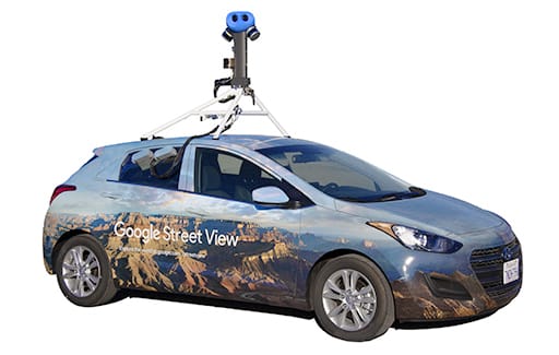
The Google Street View car
Here is what the car looks like:
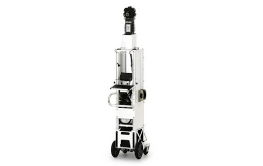
Google Street View Trolley
The trolley allows for example to access the interior of museums around the world or other places such as the White House or stadiums:
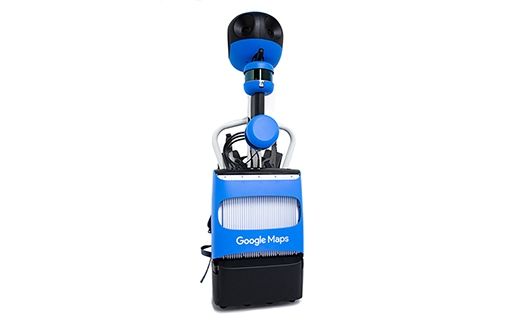
Google Street View Trekker
The Street View Trekker allows you to go where cars, tricycles, carts and snowmobiles cannot. Topped with a camera system, this compact backpack allows you to collect images in tight, cramped or walk-in locations.
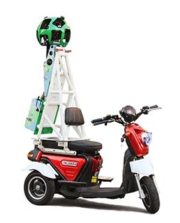
Google Street View Three-Wheeler
For cities with small, narrow streets, Google uses Selis Robin motorcycles (made in Indonesia) for its Street View tricycle. It contains an additional mast that brings more stability to the Street View Trekker.
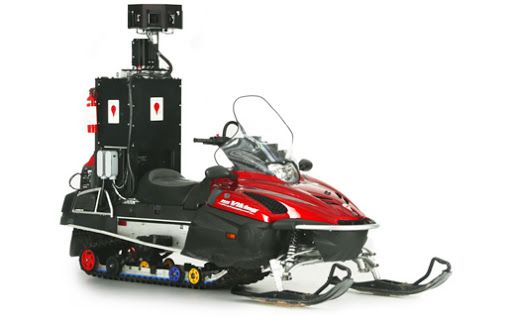
Google Street View Snowmobile
Google even uses snowmobiles in ski resorts:
Street View Tips & Tricks
How to add photo spheres in Street View?
You can also create photo spheres and add them to Street View to share your own experiences:
- either with your phone’s camera
- or with a spherical camera that can take 360-degree photos with a single touch (like the Ricoh Theta S).
- Then post them on Google Maps to share with the world.
What is Street View for?
As an individual, you can use StreetView to:
- take a virtual tour of many tourist sites around the world
- prepare an itinerary with an ultimate zoom, i.e. photos of the places you are going to cross. Very useful also when used on a cell phone.
- search for parking lots and check the access for people with reduced mobility
- study a vacation rental before going there (or signing the contract!)
As a professional:
- show your potential clients what your storefront, storefront or office facade looks like. The best way to do this is to use a virtual tour with Street View
- post pictures of the real estate you have a mandate for (the Google Maps API should help you)
- illustrate an article or a file with pictures of the places you are talking about
How to see Street View in Google Earth?
To activate Street View in Google Earth app (or its web version):
- Zoom in on a location
- When Pegman appears in the navigation controls, drag it
- Drop it to use Street View
Is Street View free?
Yes of course, like most Google products.
What are best Street View locations in the world?
You can find here a very good selection:
- Ilulissat Icefjord in Greenland
- International Space Station in Space View
- Japan’s sakura (cherry blossom season in Tokyo)
- La Sagrada Familia
- Mongolia’s Lake Khövsgöl Ice Festival
- Mont Blanc in the Alps
- Red crab migration in Christmas Island
- Rio Negro River in Amazon
- Sheikh Zayed Grand Mosque in Abu Dhabi
- The Eiffel Tower in Paris (France)
- The endangered kākāpō in New Zealand
- The Machu Picchu
- The Northern Lights
- The Uros people of Lake Titicaca
- Yosemite’s El Capitan
What is Instant Street View?
It is a search engine independent from Google, giving access to virtual tours of countless cities in the world. It is available in English at instantstreetview.com
Which version of Google to use to see my house?
You can use Google Street View if your house is close to the public space (street, road). Otherwise, you can use Google Earth in aerial or satellite view.
How to see my house by satellite live?
You can’t do it with Street View (which uses photos taken by different vehicles), but Google Earth or Google Maps allows it.
How to walk around the streets with Maps and Street View?
Activate Street View (by moving the man where you want) then click on the arrows to move around the street.